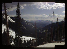
View of a mountain range and a river in the valley below. In the foreground are trees and one utility pole. Stamped on the reverse is "O. Westerman, Photographer, Breckenridge, - Colorado."
Westerman, OttoValleys
12 Archival description results for Valleys
Breckenridge, Colorado looking north down the Blue River valley. Railroad tracks are visible on Barney Ford Hill. The steep hillside is sparsely covered with thin trees. In the far distance is the snow-covered peak of Buffalo Mountain. Abbreviated title taken from handwritten caption on card mount: "Breckenridge, looking down the Blue river valley, showing R.R. track on Niggerhill to the right and Buffalo Mountain at Dillon, ten miles distance."
Westerman, OttoFrost-covered trees and tall grasses, somewhere in a mountain valley, probably near Breckenridge, Colorado.
Topolnicki Sr., John A.Title quoted from handwritten text on the item: "Ten Mile Range From Loveland Pass".
Topolnicki Sr., John A.Herders with their flock of sheep on late summer pasture in a valley below Hoosier Pass, south of Breckenridge in the Rocky Mountains of central Colorado. The shepherds take a break near a pile of weather beaten logs, probably the remains of an abandoned cabin. Circa 1970.
Topolnicki Sr., John A.Remains of wooden structures and log cabins on Bald Mountain along Boreas Pass Road, east of Breckenridge, Colorado.
Topolnicki Sr., John A.Mountain valley below Hoosier Pass, south of Breckenridge in the Rocky Mountains of central Colorado. In the foreground is a pile of weather beaten logs, probably the remains of an abandoned cabin. In the distance, sheep graze on the grassy mountain slope.
Topolnicki Sr., John A.Postcard, "Colorado Photography" by John Topolnicki. Caption on the reverse: "Tiger-On-The-Swan; 8 Miles North of Breckenridge" and "High Country - Summit County - Colorado; Virtually a ghost town, and a fine example of how old mining towns of the area looked. Tiger was a later arrival, its curious name stemming from the fact it was built to house employees of the Royal Tiger Mine and Mill. Buildings erected in the 1920's and 1930's."
Topolnicki Sr., John A.Postcard, "Colorado Photography" by John Topolnicki. Scalloped edges. Caption on the reverse includes the four (4) b's Breckenridge logo: "Autumn Along Eagles Nest - Gore Range; Colorado Hwy. 9; Summit County, Colorful Colorado" and "The sublimity of this portion of the range is unconquerable. Located between Interstate Hwy. 70 interchange at Silverthorne and Green Mountain Reservoir, a Colorado State Recreational Area."
Topolnicki Sr., John A.Postcard, "Colorado Photography" by John Topolnicki. Scalloped edges. Caption on the reverse includes the four (4) b's Breckenridge logo: "Breckenridge; Colorful Colorado; Off Interstate Hwy. 70 - On Colorado Hwy. 9; The Four Seasons Resort Area" and "From the Boreas Pass road on the Mt. Baldy road, remains in this mining area still hold the visitors interest."
Topolnicki Sr., John A.Postcard, "The Hanging Tree" by John Topolnicki. Scalloped edges. Caption on the reverse: "Snowscapes of the Colorado Rockies" and "A portion of the Gore Range as seen from interstate Highway 70, approaching Breckenridge - Dillon - Frisco - Silverthorne interchange."
Topolnicki Sr., John A.Postcard, "The Hanging Tree" by John Topolnicki. Scalloped edges. Caption on the reverse: "The Eagles Nest - Gore Range from Colorado Highway 9 - between Dillon Lake and Green Mountain Lake." and "Colorful Colorado".
Topolnicki Sr., John A.