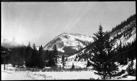
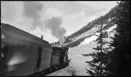
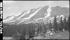
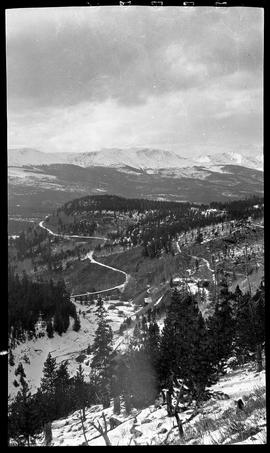
View looking northwest towards the Tenmile Range with Illinois Gulch (Illinois Park) in the foreground. The Gold Pan trestle can be seen with the railway line curving around Barney Ford Hill. The Dunkin Mine is on the right. Southeast of Breckenridge, Colorado.
Sayre, Robert H.View of a mill in a snow and tree-covered valley with a large mountain in the background. Probably Montezuma or Peru Creek area, Summit County, Colorado.
Sayre, Robert H.Snow-covered mine shaft house with rails leading out to the mine dump/tailings embankment. Probably in the Montezuma or Peru Creek area in Summit County, Colorado.
Sayre, Robert H.Snow covers the roofs of a wood-frame building, log cabin, and secondary structures (outbuildings). Probably a homestead in Montezuma or Peru Creek area in Summit County, Colorado. Mountains in the background.
Sayre, Robert H.Sheet film negatives circa 1910-1920s showing snow slides blocking the railroad in Ten Mile Canyon. Also, views of mine sites and structures east of Breckenridge and near Montezuma, Colorado.
Sayre, Robert H.Colorado and Southern (C&S) railroad Engine Number 10 blocked by snow slide on the west side of Tenmile Peak (Peak 2) in Ten Mile Canyon, near the Curtain train station south of Frisco, Colorado. One of the worst snow storms to hit Summit County in years began on December 12, 1922. Two snow slides occurred on December 15 near Curtain, one on the east side and another on the west side of the Curtain train station.
Sayre, Robert H.Colorado and Southern (C&S) railroad Engine Number 10 blocked by snow slide on the west side of Tenmile Peak (Peak 2) near the Curtain train station in Ten Mile Canyon, Colorado. Two men on top of the snow slide are attempting to shovel a path for the train. One of the worst snow storms to hit Summit County in years began on December 12, 1922. Two snow slides occurred on December 15 near Curtain, one on the east side and another on the west side of the Curtain train station.
Sayre, Robert H.The Puzzle Mine workings in Illinois Gulch (Illinois Park), southeast of Breckenridge, Colorado. The small railroad trestle or bridge uphill from the mine was located between Hookeye Curve and the Gold Pan trestle.
Sayre, Robert H.A miniature outdoor diorama featuring metal toy cars on a tiny road made in the dirt. Small, hand-lettered sign is mounted on the side of a scrap of lumber that is propped up horizontally by a short piece of wood and some rocks. The sign reads: "Sayre Gas & Oil Co". In the background a rock sits on a wood platform laid across small posts or sticks.
Sayre, Robert H.Mine workings covered in snow. Probably in the Montezuma or Peru Creek area. Summit County, Colorado.
Sayre, Robert H.West side of Bald Mountain above Boreas Pass on the Breckenridge, Colorado, side. In the foreground is mine shaft housing (note sheave/pulley wheel at top) with mine dump to the left of the building. Wood water storage tank to the right. Caption reads: "WM + AC & W 6/2/22". Probably east/uphill of the railroad tracks. The two strips of snow on the right side of the mountain are called Orion and The Duke (from left to right).
Sayre, Robert H.A man empties an ore car on the side of a mine dump at the Wire Patch Mine on Farncomb Hill in French Gulch, southeast of Breckenridge, Colorado.
Sayre, Robert H.Two men stand on mine dump tailings or talus field on the side of a steep, snow-covered mountain. Caption at bottom of image: "Alpha - 7:30 6/3/22 - ". Probably the 7:30 Mine on Bald Mountain, east of Breckenridge, Colorado. In the distance is a view of the Ten Mile Range.
Sayre, Robert H.Two formally-dressed men in a wagon pulled by two horses with a driver travel a narrow road that has been cleared in a snow slide. Probably taken in the Ten Mile Canyon, Colorado, near the Curtain train station where a snow slide occurred on December 15, 1922. Caption on right of photo has a date of 6/8/22, but that may not be correct as snow would have mostly melted by June.
Sayre, Robert H.Men dig a path in the deep snow after an avalanche buried the railroad tracks in the Ten Mile Canyon, near Frisco, Colorado. On December 15, 1922 two snow slides occurred in the canyon near the Curtin train station, one on the east side and another on the west.
Sayre, Robert H.A man sits on ore car tracks coming out of a mine adit (opening) encased with ice. Quote from caption at the bottom of the image: "Ice Tunnel 7:30 6/3/22". Probably the 7:30 Mine on Bald Mountain, east of Breckenridge, Colorado.
Sayre, Robert H.Man standing in front of what appears to be wooden framework of a derrick with a sign listing "FERRY - RATES" ranging $2.50 for a truck to $.25 for a pedestrian.
Sayre, Robert H.Looking west across to Bear Mountain above Sts. John, Colorado. A man snowshoes up the west side of Sullivan Peak (or Geneva Peak). In the Snake River drainage are mine buildings and structures covered in snow. Or, this could be the Pennsylvania mill in Peru Creek, near Montezuma, Colorado.
Sayre, Robert H.Buildings, including a log cabin, an L-shaped board and batten building, and a two-story board and batten structure in the snow covered landscape. Probably the Pennsylvania mill in Peru Creek, near Montezuma, Colorado. A mine dump is visible in the trees in the background. Tram cables can be seen from the middle left going to the upper right of the photograph.
Sayre, Robert H.A man, woman and young girl look out the window opening of a horse-drawn passenger carriage or coach piloted by two coachmen. The covered-carriage is decorated with ribbon garland around the body and streamers woven through the four wheels. All are finely dressed; one coachmen wears a top hat. There is a mansion/large house in the background. It appears as though they are traveling in an urban area, possibly somewhere in Colorado.
Sayre, Robert H.